
Who Fixes the Roads in Greenville?
Happy September, everyone!
As I’m out and about talking to people, one topic that tends to come up is the condition of our roads in Greenville County. When dealing with roads in South Carolina, one of the first facts you come up against is the scale of the road system in our state.
From a 2017 Greenville News article,
“South Carolina has the fourth-largest state-maintained road system in the nation, with more than 41,000 miles. Primary routes are major state and U.S. roads and make up 9,517 miles. Federal-aid secondary routes are less traveled local roads. They make up 10,370 miles. The last category are the least traveled secondary roads, many of them short roads.
For comparison, according to research from Palmetto Promise from 2017, South Carolina has about half the road system of Texas and more than double that of Georgia. For reference, Georgia is about 2x the size of South Carolina in land area, and Texas is about 9x larger than South Carolina.
Palmetto Promise gives some historical context about how this came to be:
“Widespread ‘state-ification’ of roads started in the 1920’s when the federal government started a highway building program that allowed states to receive aid for their state-owned roads. Many local roads quickly began to be transferred into the state system. According to Walter Edgar’s South Carolina a History, from 1946 to 1950, almost 5,000 secondary routes were paved. Following that, before the age of home-rule, legislators began to transfer local roads from their home districts in order to gain access to the resources available for state-owned roads.”
So the first question you must answer when you want to talk to someone about a road is to figure out whose road it is. In many cases, it’s a State Road, not a County Road, so it’s good to check every time.
There are a few ways to do this. First, you can look at the street sign. If you notice, most street signs have a little code on them. For example, here’s the intersection of Dan Bull Road and E Main Street in Taylors:
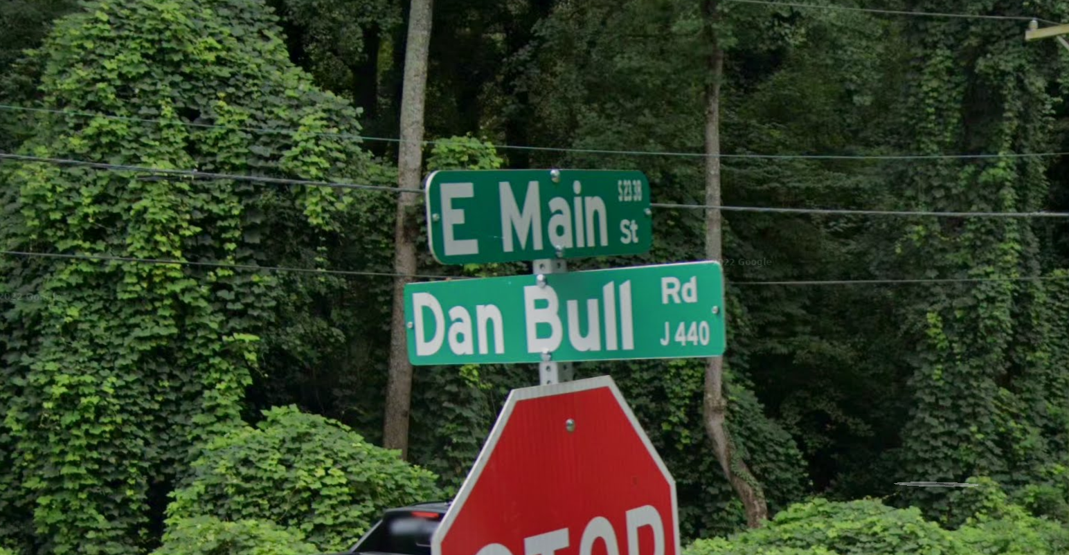
If you look carefully at the picture, you can see some numbers on the right side of each street sign. On E Main Street, it reads S 23 38; on Dan Bull Road, it reads J 440.
Looking at this chart from Greenville County Public Works, I see that County Roads begin with the letter J, and I see that Secondary State Roads begin with S and are followed by a pattern of numbers. So I can see that Dan Bull Road is a County Road while Main Street Taylors is a State Road maintained by SCDOT.
Beyond looking at Road Signs, you can also use several online tools. Greenville County’s GIS System (I’ve talked about it before here) is a wealth of information, including roads. You can see the instructions for looking up a road on the GIS system here. SCDOT also maintains a Street Finder tool. You can access it on the SCDOT website here.
Greenville County uses a “worst first” approach for annual resurfacing of the roads under their jurisdiction. They publish a list here, and County Council also approves a list annually. You can also request County Road Paving on their website here.
SCDOT publishes information about its Pavement Improvement Program on its website. Clicking the interactive map shows you where they are planning to pave soon. You can also request road maintenance on their website here.
Keeping incentives in mind, another approach to take to request work on roads is to contact your elected representative at the State or Local level. To do that, find the road you want to discuss, then determine if it’s a State or Local Road. Finally, contact your County Council Member if it’s a Local Road or contact your State House or Senate Member if it’s a State Road. You can find your representatives using this tool.
Thanks for reading along here; I hope this has been helpful! I would love to hear from you if you enjoy this type of content or what other information would be helpful for us to explain. You can reply to this email and let us know.
With that, thanks for reading, and see you next time.